Home » Transportation in Kythira » Kythira road network
Citera road network
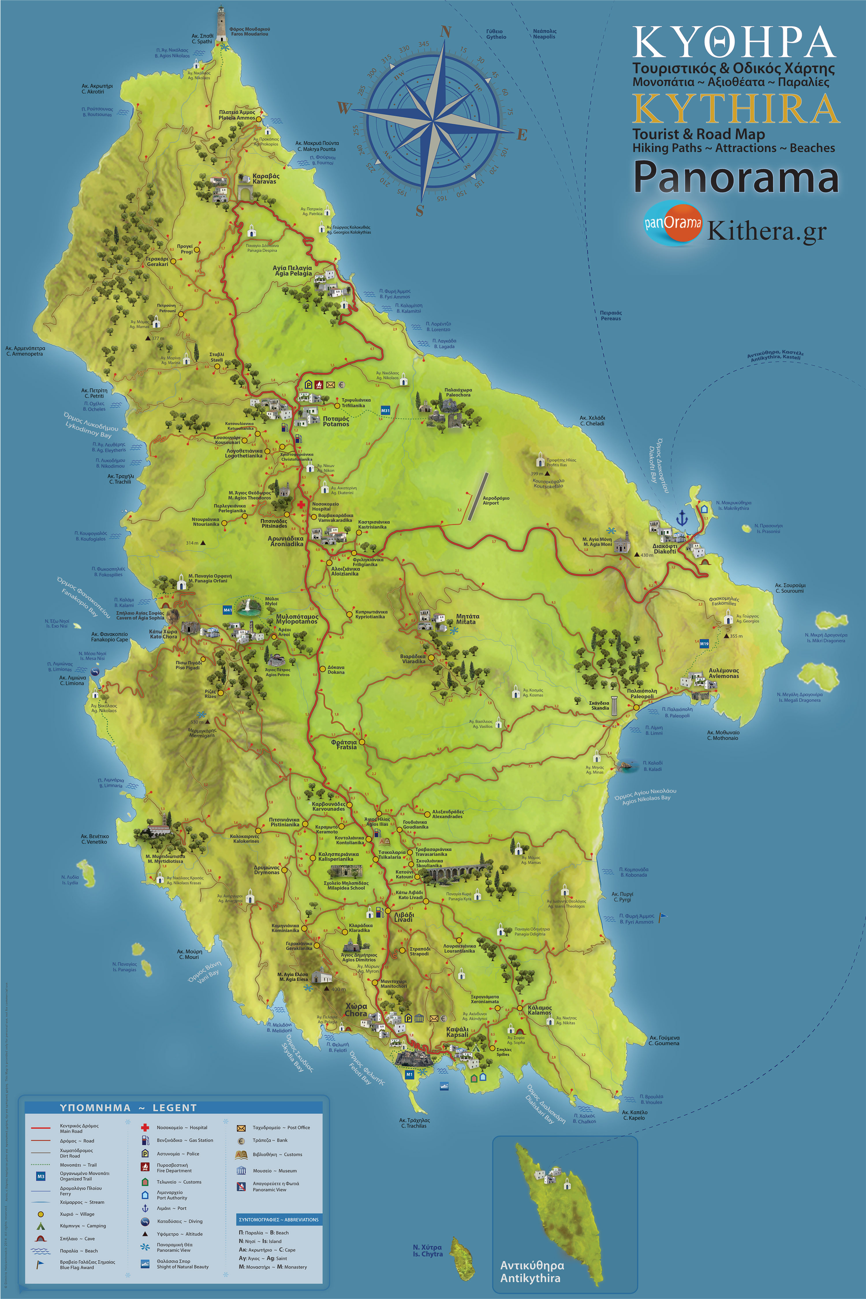
The island is of moderate size by Greek standards, and has a dense road network, consisting of asphalt and dirt roads. Kythira is crossed from north to south by a central road with dense branches to the entire area of the island. Access to most villages is by asphalt roads, but to some beaches there are dirt roads. Most roads maintain the minimum width for two-way traffic, have many curves, which often cover the visibility of vegetation, so driving should be very careful, and drivers should be patient, and follow traffic rules, especially in the summer season.
The average speed limit is about 40-60 kilometers per hour, which gives us the opportunity to enjoy truly wonderful routes through magnificent landscapes without stress. In Kythira there are 4 gas stations along the central road. Two of them are located at the southern entrance of Potamos, located north of Kythira, another one in Kontolianika, and in Livadi in the center-south of the island.

Hover your mouse over the map to see a 2x zoom. Actual download size is X4 larger, high resolution, 100% JPG Quality.
ROAD & TOURIST MAP OF KYTHIRA
The map is compatible for all mobile phones, ipads, laptops and PCs ~ Download Map of Kythira ➼Driving in Kythira – Information & Precautions
The road network in Kythira is generally good and paved, however there are some peculiarities that require attention from drivers, especially those visiting the island for the first time.
Useful Tips & Advice:
Drive at low speeds, especially on narrow country roads with curves and low visibility.
Pay attention to animals on the road, such as goats or sheep, especially near rural areas or at dusk.
Do not rely solely on GPS – some areas have poor signage or weak signals, so it is a good idea to have a printed map.
Avoid driving at night on unfamiliar routes, as many roads are unlit.
Have a full tank of gas before heading to isolated beaches or areas – gas stations are not everywhere.
Be careful on dirt roads, which are found near many beaches. If you do not have a suitable vehicle (e.g. SUV), it is preferable to continue on foot.
Additional Information:
Most routes take about half an hour, but curves and elevation changes can slow down traffic. Road markings are satisfactory on main roads, but more limited on secondary routes.
Driving in Kythira is pleasant and gives the opportunity to discover beautiful landscapes, but it requires responsibility and attention. With a little preparation, you can enjoy the journey safely!
